
blah blah blah
Nancy Pond Trail
Length: 8.6 miles out-and-backDifficulty (click for info): Very Hard
Elevation Gain: 2290 feet (+140 feet on return)
Rating (click for info): 9/10
Elevation: 3095' (Nancy) and 3093' (Norcross)
Driving Directions:
Trailhead and parking area are on Rt. 302 in Hart's Location, NH (cascades are in Livermore), 17.7 miles south of Rt. 3 and 11.3 miles west of Rt. 16. Look for a small pull-off on the west side of the road with a trail sign, across from a clearing by the railroad tracks. If travelling eastbound, it will be on your right 0.9 miles after passing the entrance to the Notchland Inn. Click here for a Google map.
About the Hike:
Hiking the Nancy Pond Trail serves up a wonderfully pleasing variety of scenery. Tall waterfalls, peaceful ponds, lush bogs, and wilderness vistas are included in one all-encompassing package. It's the only trail through the Nancy Range, a cluster of mountains just below 4000 feet on the southwestern end of Crawford Notch. The hike starts with a gentle approach into the valley, gets more rugged as you climb beside crashing cascades, and culminates with an atmospheric stroll through a boggy plateau to a pair of high-country wilderness ponds with stunning views. It's also a good place to look for solitude on busy days, as the Nancy Range tends to be a less-frequented area.
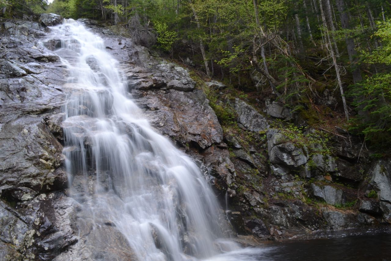
The Nancy Pond Trail begins just south of Crawford Notch, at the base of the valley around the Saco River. Head into a tall tree canopy past the trail sign and you'll be able to judge the character of the trail for the first portion of the hike - a fairly mellow, smooth pathway heading uphill at easy grades. You'll find a kiosk with a trail map set back into the woods about 0.1 miles. In the first half mile, the trail runs in proximity to several houses. Past the kiosk, the trail crosses a minor brook, and in 0.2 miles, crosses Halfway Brook, usually easy to step across on stones and a segment of ledge. Soon the trail joins up with a woods road and follows it uphill. This junction is more noticeable on the return trip, where you should take note to turn right off of it. In a half mile past the brook crossing, the trail approaches the top of a high, steep bank from which you can look down onto Nancy Brook. Pass a red-painted boundary monument demarcating a corner of the White Mountain National Forest. At this point, a sign also marks a private trail coming up from the Notchland Inn. The trail diverges away from sight of the brook and continues gently uphill on a wide forest corridor, and in 0.3 miles, crosses a nameless brook draining off the slopes of Duck Pond Mountain. Another half mile of easy terrain follows as the trail parallels Nancy Brook at a distance. After a narrower section where the pathway cuts across the hillside, it turns and crosses a wide, boulder-tossed section of Nancy Brook. Most of the rocks at this crossing are large and immobile, but high water can cover up some of them and make crossing difficult. On the other bank, weave through an area damaged by washouts, where a dry channel of the brook has lacerated part of the trail. Fresh blazes guide you around the boulders to the trail route. Soon the trail crosses another small brook, and 0.2 miles upstream, passes scattered artifacts evidencing the remains of an old mill site. Just 0.1 miles past this, it turns right onto a series of switchbacks leading uphill to bypass a long section down low next to the brook that was washed out in a flood. After a moderate climb, the trail traverses across the hillside far up above the brook, then descends through scattered large boulders back to the brook, reaching it after a total of a half mile. The trail crosses crosses Nancy Brook for a second time, now within viewing distance of the first cascade. It wraps around through the woods briefly and emerges on a bank with a picturesque viewing window of the lowest, and most singularly impressive, of the Nancy Cascades. It is a delicate, fanning waterfall, and is great to photograph. You can approach the edge of the pool beneath the tumbling cascade by walking out on the stones around the edge. In higher flow conditions, the mist permeates the air.
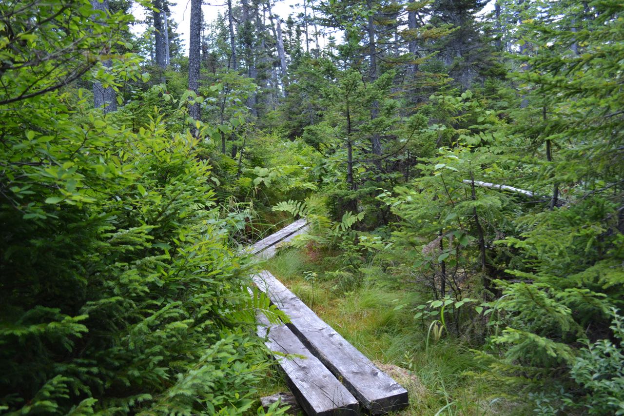
Beyond the first cascade, the trail surmounts the sharp slope beside the cliffs with a series of switchbacks. It does a good job of eliminating the severity of the slope, but rough terrain persists, with plenty of roots and rocks to climb over on the narrow trail. At the second switchback, the trail comes into view of the brook again in the middle of the second cascade, more of a low-angle water slide. Just over the edge at the bottom of this cascade is the top of the first. The trail then passes a window in the trees that allows for a view out toward Stairs Mountain and Mt. Resolution and stays out of sight from the brook. After climbing up through several more turns, the trail levels out after 0.4 miles and joins up with the brook. Another sizeable cascade is just downstream in the ledgy brookbed from the point where the trail comes in, but is not quite visible from the trail. Now that you've attained the height of a gentle plateau, enjoy the peaceful brookside stroll through a gorgeous environment where wildflowers are abundant springing up out of the moss beside the trail. It slowly drifts away from the brook, crossing a few muddy areas on bog bridges. In 0.2 miles, it crosses a smaller branch of the brook, which is the outlet from Nancy Pond. It turns to follow this brook upstream, crossing it two more times, one of which requires a tricky step down from a rock where an old log bridge has rotted away. The trail now utilizes long boardwalk chains to pass over the soggy ground, where rhodora grows out of the low brush in abundance. The environment becomes increasingly more lush and boggy, and the trail passes through an open area before ducking back into the woods. Back on drier ground, the trail climbs up through rows of short spruces, descends slightly, and arrives at serene Nancy Pond after 0.4 miles. The outlet is visible through the trees as you approach it; continue along the trail, as it follows the shoreline on yet more boardwalks, and soon you will make it to an opening where a beaten path leads out into the wetlands surrounding its shores. From this spot midway along the pond, you have a good view of the peak Mt. Anderson across the quiet waters.
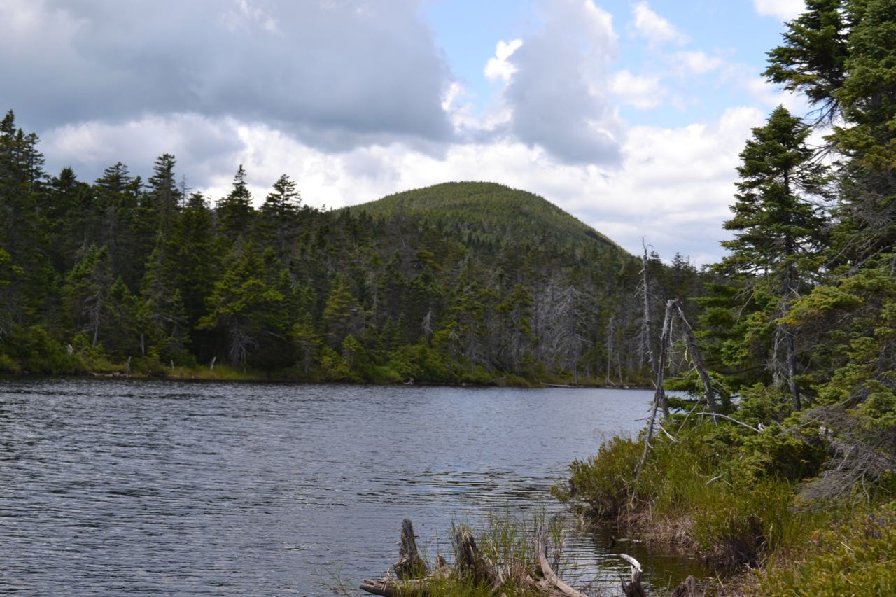
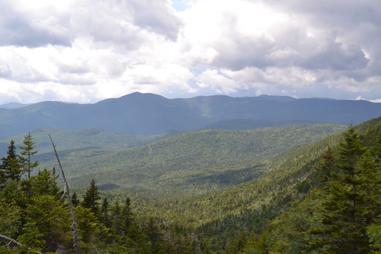
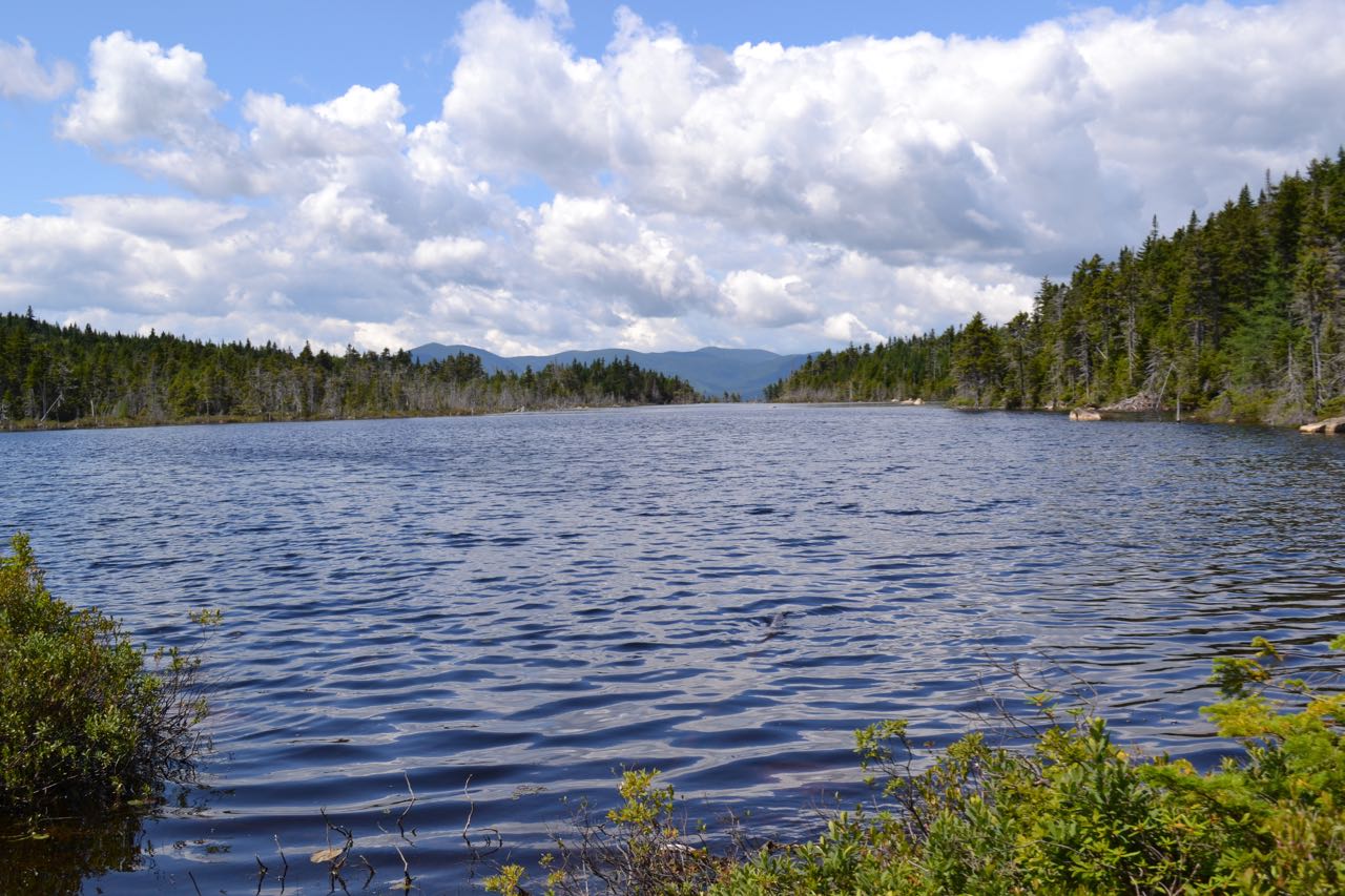
There is one more good viewpoint over the pond as you follow the boardwalks through the haunting landscape. The trail passes the end of the pond 0.15 miles from where it first joined the shore and continues through the surrounding swamp. Soon it crosses the boundary into the Pemigewasset Wilderness, marked by a signpost, and comes within view of an open bog known as Little Norcross Pond in another 0.15 miles. About a tenth of a mile further, a spur path leads straight ahead to the near shore of one of the most beautiful ponds in the region, Norcross Pond. From the sandy and rock-rimmed water's edge, you can enjoy magnificent views across its waters to the Twin Range. The main trail hugs the shoreline and heads 0.3 miles to the opposite end, with many more opportunities to look out over the water. The moss-lined trail swings briefly away into the woods and returns to the outlet of the pond, passing an unoffical trail to Mt. Nancy on the right. Here, at the northwest end of the pond, the outlet brook spills over open ledges, pouring through interesting chutes and careening down the hillside. Out over the opening, the Bond summits and the Shoal Pond ridge below them come into clearer view. The marvelous combination of scenery here is the highlight of the hike!
Printable directions page