How to use this website
Welcome to NHFamilyHikes.com! Here we do our best to maintain a thorough library of hikes in the state of New Hampshire. We have been online since
2014, and our purpose is to provide hikers with a comprehensive yet easy easy-to-use information resource that's aimed toward families and novice
hikers but still encompasses useful information for experienced mountain trampers as well. If the hike you're looking for is on NH Family Hikes, we
hope that you will be able to learn everything you need to know right here before you head out into the woods without consulting multiple other guides
to find all the information you need. For every hike we have here, you will find quick statistics, driving directions, a trail description tailored
to follow along with as you go, and a multitude of photos.
To start picking out a hike, go to the "Find a Hike" tab. If you already know
what you're looking for, go right to the full index of hikes in alphabetical order. If you're looking to plan a trip but don't quite have a destination
in mind yet, you can search our library by scenic region, type of hike, and difficulty, and our helpful trip-planning guide will display ratings for
each result so you can easily match a hike with the conditions of the day and your preferences. For more on the trip-planning guide, see the section
below.
If you are interested in hiking regularly and want to try making progress on one of our state's many hiking challenges, go to the
"Quests" tab, where you will find several pages with an introductory guide, quick information tables, and links to each of our individual guides to
the hikes within that particular list. Visit the "Articles" tab for miscellaneous resources, which we update now and then. For information on Who
made New Hampshire's mountains, click here. Feel free to reach out to us with questions or comments at
NHFamilyHikes@gmail.com.
Difficulty Ratings
| Beginner | Anyone can do hikes rated 'Beginner'. They typically involve short walks on flat terrain, and there may be occastional inclines. At most, it will be steep for very small climbs. These hikes will not usually take more than an hour and a half and are best visited as a side trip, unless you live very close to one. |
| Easy | Easy is a good difficulty level for most young children. 'Easy' hikes are never more than five miles, and will not typically have any very rough terrain. You can expect to see moderate to difficult inclines, but the steeper the incline, the shorter the hike will be. You can usually complete two nearby 'Easy' hikes in an afternoon. |
| Moderate | Moderate hikes can have a rough trail with a grade about the same as an 'Easy' hike, but with more prolonged steepness and more distance. Similar to 'Easy', the more difficult the grade and trail surface, the shorter the hike will be, and vice versa. A hike with this difficulty could be done in an afternoon by itself. |
| Hard | With hikes rated 'Hard', you can expect to see constant, difficult grades, with some occasional rock scrambling and/or extreme steepness. 'Hard' hikes have a moderate to long distance, never more than eight miles. Trail surfaces are always rough. These hikes can take anywhere from a half day to a full day. |
| Very Hard | 'Very Hard' hikes should be attempted only by those who have had much hiking experience and are conditioned for long distances and difficult climbing. Be prepared for constant strenuous grades and rock scrambling. These hikes will not be more than ten miles long, and may be much shorter if the trail is extremely steep. Do not plan any other destinations on the day you do one of these hikes. |
| Extreme | 'Extreme' is the hardest difficulty level on this website. You should make sure you can complete 'Very Hard' hikes fairly easily before trying an 'Extreme' hike. Hikes are usually rated this difficulty for having a terribly rough trail surface, lengthy stretches of severe grades, very difficult distance, or all of these. Similar to 'Very Hard' hikes, these hikes should not be done on the same day as any others. There is no limit on how long 'Extreme' hikes can be. |
Distance - Distance is always given round-trip.
"Out-and-back" is the standard type of hike; The destinations are reached by a single trail, which you must hike both ways.
A "loop" hike is also common; One or more trails are used to create a continuous trip around the destinations, so that you never have to retrace your steps.
"Out-and-back with loop(s)" is a combination of the two; A single trail is hiked to a certain point, where a loop is used to visit the destinations and return to that point.
Elevation (of mountains or lakes) - The altitude above sea level of the summit or water.
Prominence (of mountains) - Prominence is a measure of how much a mountain stands out from its surroundings. It is the vertical distance between the
mountain's summit and the lowest point on the highest ridge connecting it with a higher mountain (the key col). If a
mountain has a prominence of 500', that means if you are standing on the summit and you want to walk to a higher place, the very minimum vertical
distance you must descend in order to climb up to another place higher than the summit is 500 feet. To learn more about prominence, see our article
here.
Elevation Gain (of ascending trails) - The vertical distance climbed from the trailhead to the destination. This figure, along with the distance and a
topographical map, can tell you a great deal about the difficulty of the hike. If any amount of climbing uphill is required to return to the beginning
of the hike, this figure is also listed.
Height (of waterfalls) - The height of the waterfall.
River (of waterfalls) - The water source of the waterfall.
Type (of wetlands) - The ecological type of the bog or swamp.
About NH Regions
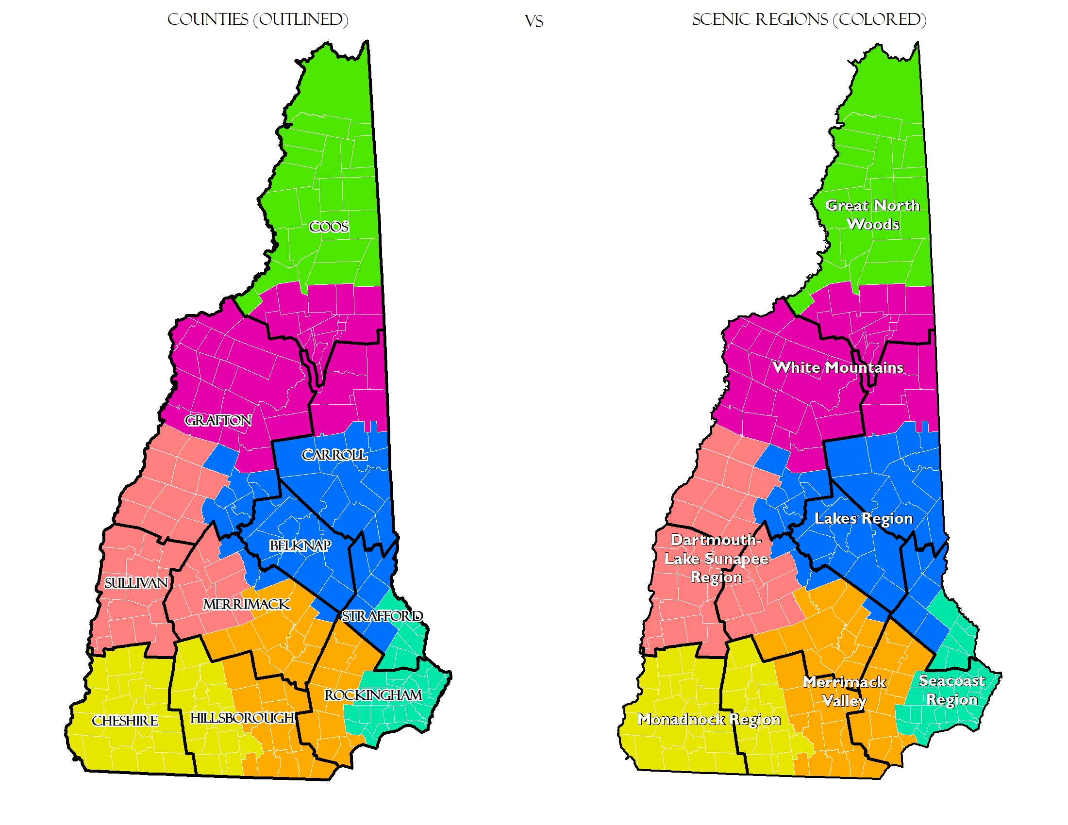
On this website, you can search our library of hikes by difficulty and category in any of New Hampshire's seven scenic regions. For those
unfamiliar, below is a map to display the areas covered by each scenic region and compare them to counties for reference. Here are brief
descriptions of the hiking opportunities in each region:
Seacoast Region - This is the smallest, lowest region and is the most limited for hiking. So far we have only found five notable hikes in this
region. Two are short climbs to low hills with scenic views and three are walks near the ocean.
Merrimack Valley - Also mostly flat terrain and urban like the Seacoast. Most hiking opportunities are found in state parks and nature preserves.
There are no significant mountains, but there are a few small hills with scenic views to climb.
Monadnock Region - By far the best hiking in southern NH is found here. The centerpiece is of course Mt. Monadnock, but the Wapack Range (the only
named mountain range this far south in our state) is another great feature, being completely traversed by the 22-mile Wapack Trail, which provides a
multitude of short day hikes to small, ledgy hills with the region's best views. There are also plenty of isolated hills to hike in nearly every
part of this region. Finally, the Monadnock Region contains the best (and only) waterfalls of southern NH.
Dartmouth/Lake Sunapee Region - This region does not have quite the volume of hiking opportunities as the Monadnock Region, but it does have far more
isolated mountains with trail networks of their own, including Cardigan, Kearsarge, Ragged, Smarts, Cube, and Sunapee, which all have more
interesting views than Mt. Monadnock. There are also several hidden gems that are overshadowed by these big names as well.
Lakes Region - Unquestionably the best hiking outside of the White Mountains is found here. Three distinct small mountain ranges with extensive
trail networks are positioned around the many lakes. Their many open summits almost all have excellent views of the two major lakes, Winnipesaukee
and Squam, at lower than average effort. The Belknap Range in particular has one of the best-maintained trail systems in our state. There are a
few waterfall and forest walks in the area that are impressive as well.
White Mountains Region - This is the reason New Hampshire is known for its hiking. Any type of adventure you are looking for you will find in the
White Mountains. Mountains range from beginner climbs with disproportionately good views like Bald Mountain in Franconia to the "world's most
dangerous small mountain", Mt. Washington of course. The trail system, maintained by a huge number of outdoor clubs, is so massive and
interconnected that one could travel from one side of the region to the other using almost only hiking trails, and most mountains have a variety
of trail routes to choose from. Scenic views from the top vary wildly in different ranges and areas - some smaller mountains will have stunning
360-degree views, while a peak that is 3000 feet higher might be mostly forested. Also, almost all of NH's famous waterfalls are found in the
White Mountains. It would take an individual many years to completely get to know the sheer variety of the White Mountains, and the excitement
of discovering all there is creates a habit of returning time after time. Because of the volume of hikes in our library in this one region,
we have split it into southwest and northeast for our search. We have defined the southwest portion to include hikes
which are accessible from near I-93 or roads to the west and from near the Kancamagus Highway or roads to the south (most notably Rt. 49, Rt. 113A,
and Rt. 3 until Twin Mountain). The northeast portion includes hikes which are accessible from near Rt. 302 or roads to the north and east (most
notably Rt. 2, Rt 16, and Maine Rt. 113 through Evans Notch). We have separated the region out this way because the southwest portion will cover
most hikes that are under 1.5 hours drive from Concord, and the northeast portion will cover most hikes that are around 1.5 hours or more.
Great North Woods - This region, despite its scenic beauty, has far fewer hiking opportunities than the White Mountains because of its remoteness.
More hiking is found in the southern part, closer to the White Mountains. The region has several significant mountain ranges which rise to heights
above anything south of the White Mountains, but very few of the high peaks actually have maintained trails to the top. The lack of any sort of
trail system like in the Whites is due to the increased driving time from populated areas - most people don't realize that it takes almost two and a
half hours to reach the top of NH after leaving I-93. The few hikes that you will find in any part of this huge region,
however, are iconic.
To enable the new trip-planning guide, check the box with the same description on the "Find a Hike" page before searching. Now when you search
for hikes, each result will display a color-coded list of eight attributes, ranked on a scale of one to five that will help you choose the right
hike for whatever weather your day has or whatever season you are hiking in. You can get details on the system we used to rank each hike on our
scale by hovering over each icon in the legend at the top of the search results, but here are a few extra tips on how to use our guide. Below are
the eight attributes we have ranked our hikes on and how you can use to decide which hike to choose for the current conditions.
Please note that while we try to present the facts in the best way for our website viewers to use, some things, like how suited a mountain view
is for fall foliage viewing, are inherently subjective. In fact, placing any of these attributes on a 1-5 scale forces opinions onto them.
We have written this guide from personal experience only, and some may disagree with our ratings. As far as these pertain to safety, you alone
can determine whether any particular hike is suitable under any circumstances. While we would like to boast that using our guide will ensure
finding a safe and fun adventure on any kind of day, it is not sufficient to be completely sure of either of those. Other resources, such as
trail conditions websites, can boost your confidence that you have made a good choice, but there is really no way to be certain that everything
will go as planned when dealing with the outdoors, especially here in New Hampshire. If you think we should make a correction to any specific
rating given to a hike by this guide, please let us know by sending a message to the email address found at the bottom of this page.
Summit Visibilty - This attribute ranks the extent of the summit view of the mountain(s) on the hike if applicable. You can use this to pick a
far-reaching view if your day has perfect viewing conditions or stay with a limited view on a cloudy or hazy day. Notice that our process for
rating summit views does not include the number of directions you can see from the outlook. We are talking about how much you can actually see
in any direction, because that is what commonly changes due to summer humidity and haze. This is something you can judge from anywhere that you
can see a distance. For example, while driving down a hill where you can see for a few miles over the trees, you can observe how well you can
see the far-away terrain to decide if it is a good day to climb a mountain from which you can see a great expanse or if it is better to hike to
somewhere that has a view of nearby mountainsides within a few miles. Note - we will also provide this ranking for any non-mountain hikes that
have a view.
1 - Extremely close-up or low view
2 - Only mountains in same range or area visible
3 - Several ranges visible
4 - Distant mountains across several ranges visible
5 - Horizons clearly visible
Trail exposure - This attribute ranks how open to the weather the route taken by each hike is. This is helpful to know if it will be cold
or windy so that you can choose a hike with more protection from the elements. This is also a good idea to know because it will help you
determine how easily you can escape or take shelter in unexpected bad weather. To be better prepared, you should read the trail descriptions to
see exactly where along the hike the openings will be. Note that if the majority of the trail is completely forested, but there is a short
open section to get to the summit of a mountain, we will rank the hike with disregard to the negligibly short section at the top, because
the final trail section will be included in the summit exposure ranking.
1 - Entirely forested
2 - Minor ledges/openings
3 - Notable exposed areas
4 - Prolonged exposed areas
5 - Long and completely exposed areas
Summit Exposure - This attribute ranks how open to the weather the summit of a mountain in particuar is if applicable. Whereas the trail exposure
concerns safety in adverse conditions, knowing summit exposure is more for comfort, since shelter can be taken in bad weather by simply leaving
the summit and walking down the trail, or just turning back before you arrive. Also remember that elevation is a major factor in summit conditions.
A 2000-foot mountain rated as a 5 might be safer and more comfortable when cold and windy than a 4000-foot mountain rated as a 3.
1 - Totally sheltered
2 - Minor opening to wind
3 - One side exposed
4 - Some shelter
5 - Totally exposed
Water crossings - This attribute ranks the difficulty of walking across any brooks that the trail crosses on its way to the destination. There
are almost no hikes in New Hampshire that require fording or wading through a river, but quick changes in precipitation or snowmelt can make
water levels rise and cover stepping stones, forcing you to turn back or get wet. The most important thing to remember is that water levels
may be very different in multiple regions, so you should always watch for this while traveling to any hike that requires crossing water. A quick
glance to each side while driving across a bridge can tell you if rivers are raging or just trickling.
1 - None or not considerable
2 - Small brooks only considerable at very high water
3 - Avoid at high water
4 - Considerable at any water level
5 - Major obstacle; visit only during dry times
Foliage viewing - this attribute ranks how suited a mountain is for observing autumn colors if applicable. Great foliage hikes are those that are
low-elevation compared to the surrounding area and overlook nearby lake or brook valleys. We also provide this rating for ponds and bogs.
1 - Too high or removed from foliage area
2 - Foliage areas at a distance but not close
3 - Average foliage viewing
4 - Near at least one good foliage area
5 - Surrounded by prime foliage areas
Crowds on trail - This attribute ranks the popularity of a hike. Many of New Hampshire's iconic outdoor destinations are getting to be very
overused, and some hikers want to know where to go to avoid crowds on the weekends.
1 - Totally unknown (good for weekends/holidays)
2 - Obscure destination that a few people know about
3 -
Enough to know you won't be alone
4 - Fairly popular area (avoid at busy times)
5 - Overcrowded (only visit early weekdays)
Parking availability - This attribute estimates how much space is available to park at trailheads. Be aware that a hike we rated low in the
previous attribute (crowds on trail) is not guaranteed to have available parking, since some obscure hikes begin at parking locations that are very
busy for other reasons.
1 - Limited roadside parking
2 - 5-10 cars
3 - 10-15 cars
4 - 15-20 cars
5 - 20+ cars
Danger when wet - This attribute ranks how dangerous each hike would be under slippery conditions. We thought about the trail surface of each
hike, particularly how much rock or ledge walking is involved and how steep and long it is. You must remember that when conditions are
exceptionally slippery, like immediately after a downpour, or when spring ice remains, almost any trail that includes even the smallest rocks
or an incline can be dangerous. You must also remember that even some trails we rank as "safe" when wet are not neccessarily enjoyable. Many
trails are prone to mud or have poor drainage, leading to running water along the footway, but this would be too difficult to rank based on personal
experience.
1 - Very low danger
2 - Typical rocky terrain but nothing too unsafe
3 - At least one spot that could be difficult when wet
4 - Multiple risky sections
5 - Very dangerous in wet conditions