blah blah blah
Zeacliff
Length: 7.8 miles out-and-backDifficulty (click for info): Hard
Elevation Gain: 1750 feet
Rating (click for info): 8/10
Elevation: 3757'
Prominence: 10'
Driving Directions:
Trailhead and parking area are at the end of Zealand Road in Bethlehem, NH (Zeacliff is in Lincoln). (Seasonal road - check status on TrailsNH to verify gate status). Turn west onto Zealand Road from Rt. 302, 2.2 miles east of Rt. 3, at the signs for the Zealand Campground. Drive 3.5 miles, all the way to the end of the road, passing several campgrounds and other trailheads on the way. The road ends at the parking area on the left one mile beyond the Hale Brook Trailhead. Approaching the parking area, there is a long row of overflow parking on the right side of the road just before the bridge. Be aware that the parking area fills up very quickly on weekends and busy times, and roadside parking is banned near the end of the road outside of the main lot and overflow lot. Click here for a Google map.
About the Hike:
The walk through the Zealand Valley on the Zealand Trail is one of the most rewarding and scenery-rich strolls in the White Mountains, with stops along the pristine Zealand River, vistas of wild mountain slopes across the open expanses of pretty marshes and ponds, and beautiful cascades. Once ravaged by fire during the logging operations of the early 1900s, now no evidence remains of this devastation in one of the White Mountains' most scenic valleys. Most hikers use the Zealand Trailhead as a launching point for multi-day backpacking adventures, as it has access to the AMC Zealand Falls Hut and multiple popular campsites including Ethand Pond and the Guyot Shelter up in the middle of the Mt. Bond ridge. But the Zealand Trail itself is abundantly worthwhile to visit by itself and can be used for several nice day or even half-day hikes, including to Zealand Notch. Hands down the scenic highlight of this area without venturing too far toward the Bonds is Zeacliff, a magnificent clifftop outlook over the eastern Pemigewasset Wilderness. Despite climbing to over 3700 feet, the ascent to the top of the ridge is relatively mild, just a steady and somewhat rocky climb. The views from the outlook across a remote wilderness area with the rugged terrain of Zealand Notch up close and towering peaks afar rivals more expansive views from much higher peaks and definitely earns a place in lists of the most scenic views in the White Mountains.
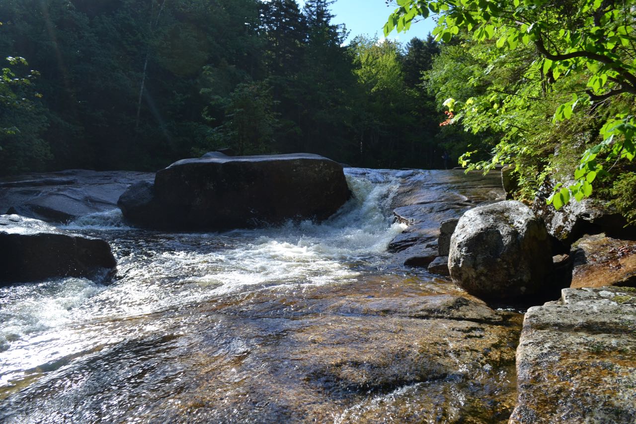
From the end of Zealand Road, head out on the gravel path at the start of the Zealand Trail, passing the signs directing to the AMC hut. It leads along the flat and smooth grade for 0.2 miles before peeling off to the right on a relocated portion of the trail. For the next 0.4 miles, it goes over rough roots and rocks, crossing several tiny brooks. It heads uphill briefly, levels off, then drops back down to the orginal trail, where it becomes much smoother again. It leads under a high canopy of conifer trees, crossing a wide wooden bridge, and leads up to the bank of the Zealand River in 0.2 miles. Here on the left side of the trail there is an opening to look over a small cascade in the ledgy riverbed. The trail swings to the right here and continues to parallel the river at a distance as the smooth, wide pathway ascends into the valley at very gentle grades. In 0.7 miles, it crosses a bridge over the Zealand River, then crosses a smaller stony brook. In quick succession, it crosses the main river again on a bridge and another smaller brook on large stepping stones.
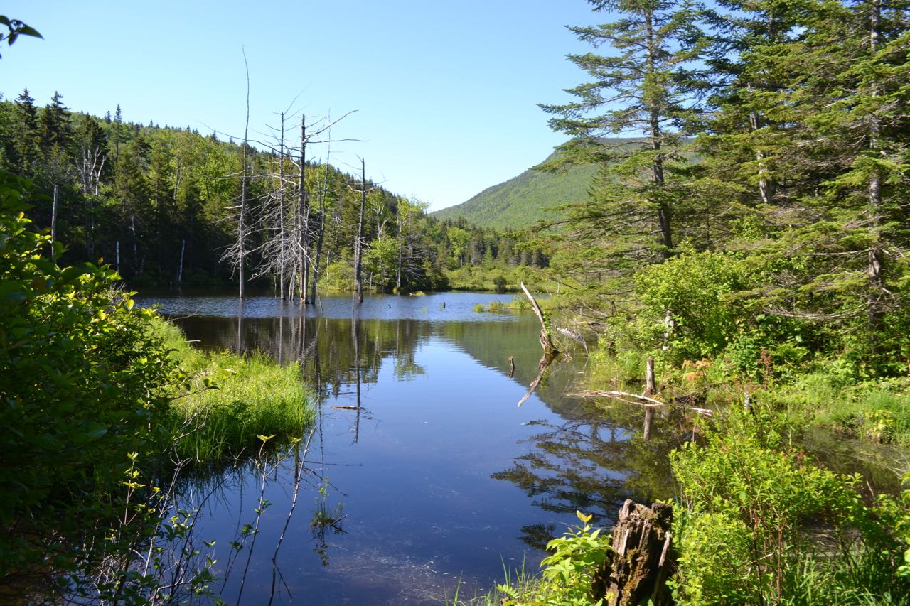
The gravelly path soon comes out into an open area, 0.2 miles from the first bridge, as the river finds its beginning in a long chain of wetlands leading up to the height of Zealand Notch. It follows a narrow elevated path through the bushes, where wildflowers abound, before crossing the open water on a long boardwalk. Take your time as you cross this bridge, as you'll enjoy views over the marsh of the steep wall of Zeacliff not too far away. On the other side, the trail turns toward the water and follows it closely, with a few more mountain views. The trail then heads on a long straightaway just off the side of the marsh, with one minor crossing of a gravelly brook in the middle. At the far end of the marshes, step just off the trail at break in the trees for a view of Mt. Tom over the grassy open water. 0.6 miles from the first bridge, head straight through the junction with A-Z Trail. Just beyond, the trail crosses the Zealand River one last time at its very headwaters in the marsh, with views of Zeacliff Pond Peak to the right. It crosses the unnoticeable highest point in Zealand Notch, where it comes up to the side of Zealand Pond. Now on the other side of the notch, the water from this pond drains into a different watershed, following Whitewall Brook and not the Zealand River. About halfway through, a spur path leads to the edge of the pond, where you can look over the clean open water toward the hillside on the lower part of the Zealand-Hale ridge. Look closely in the trees and you can see the cascades above Zealand Falls. The trail leaves the pond, and in 0.2 miles from the bridge, arrives at the trail junction with Twinway.
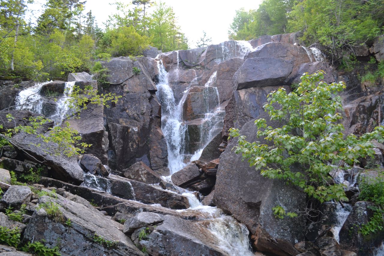
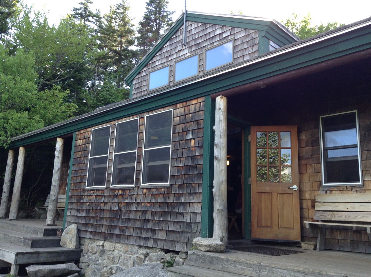
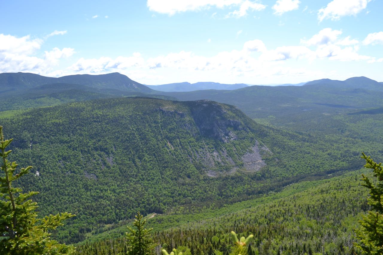
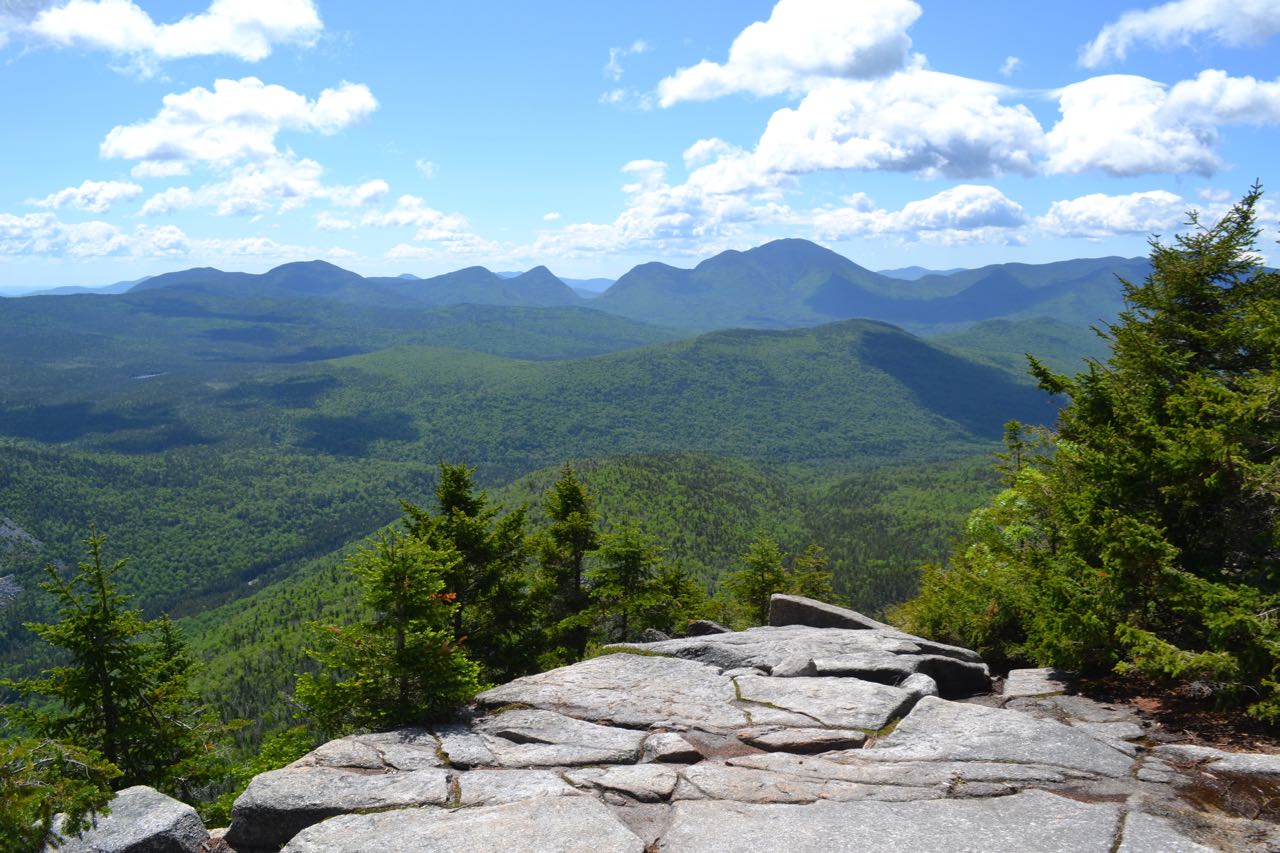
The trail leads through a small wet area, then passes a set of cascades on Whitewall Brook. Walk out onto an island in the middle of the brook for the best perspective. The trail now becomes rocky and begins to climb more steeply. At a sign on the left, a spur leads to Zealand Falls, an unusual and impressive waterfall, distinguished by its rectangular central chamber, which two cascades pour into from opposite sides. The trail climbs steeply to Zealand Falls Hut, reached at 0.2 miles from the Zealand Trail. Here, there is a limited view over the trees of Whitewall Mountain. Before continuing on the trail, follow a spur path to the left out to Whitewall Brook, where, alongside cascades, there is a view down to Zealand Pond. Beyond the hut, the trail follows the brook. Several herd paths lead out to more cascades and pools. Not too far from the hut, bear left where Lend-a-Hand Trail goes right. The trail then makes a somewhat difficult crossing of Whitewall Brook, followed by one more major brook crossing and several tiny stream crossings. Now, it climbs steadily and steeply through the forest for a mile. Near the end of its climb, the trail swings to the left, soon emerging on ledges. Wildflowers line the trail as it heads toward Zeacliff. Turn left at a view sign and walk out onto the magnificent Zeacliff outlook.
From the sunny ledges, you have a sweeping vista over the eastern Pemigewasset Wilderness. Directly below you is Zealand Notch and the talus on the side of Whitewall Mountain. Above is the Willey Range, with the Presidential Range behind. To the right of the Willey Range is the southern Montalbano Ridge. Rising from the vast valley is low Shoal Pond Ridge, with Shoal Pond at its northeast end. Across the valley is the Nancy Range, separated from massive Mt. Carrigain by deep Carrigain Notch. To the far right is Mt. Hancock. By walking down to a lower ledge, you can glimpse Mt. Bond.
Printable directions page