

blah blah blah
The Inlook
Length: 3.7 mile loopDifficulty (click for info): Moderate
Elevation Gain: 1500 feet (+0 feet on descent)
Rating (click for info): 6/10
Elevation: 3636'
Prominence: 11'
Driving Directions:
Trailhead and parking area are on Pinkham B Road in Randolph, NH. From Rt. 2, 7.9 miles east of the junction with Rt. 115 and 4.5 miles west of Rt. 16 in Gorham, turn south onto Pinkham B Road. This is just east of the major Appalachia trailhead and at the bottom of Gorham Hill. Drive just 0.2 miles down this road and pull into the parking area on the right. Click here for a Google map.
About the Hike:
In the dense trail network known as Appalachia, this lower-elevation loop on the quieter eastern side of the area explores a sharp rocky spur low down on Gordon Ridge, the main ridge extending due north from Mt. Madison. The Inlook is so named because the ledges on the ridge face into the narrow, steep-walled valley of Snyder Brook, beneath the towering summits of the Northern Presidentials. There is still quite a bit of ruggedness to even these lower slopes, and some of the climbing on the Inlook ridge is quite steep. For over a quarter mile as you climb the ridge, you'll traverse ledge after ledge with increasing views not only into this striking valley but also out to the mountains to the west and north. The hike described here is a loop over the top of the Inlook (which is only low by comparison to the mountain range it's in). With some rough terrain and steep pitches on both sides of the ridge, it's a fairly brief hike but not easy. As an added bonus, the route you'll take passes some waterfalls on the way down, with the option to detour to Hitchcock Falls.
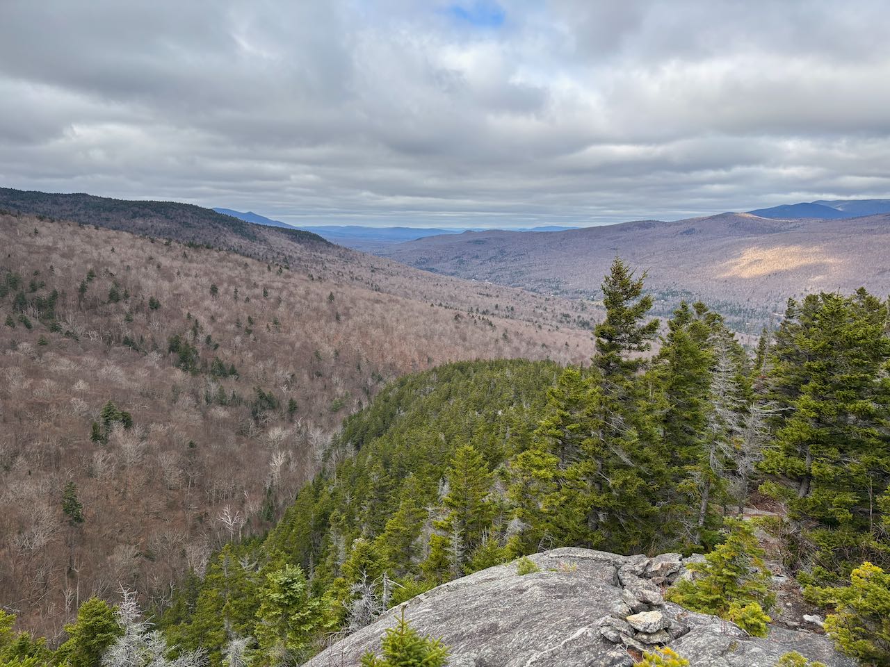
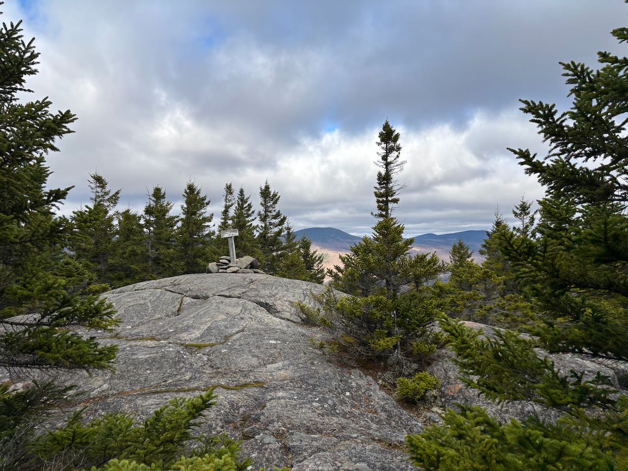
From the Randolph East trailhead, follow the trail across the Presidential Range Rail Trail to a junction in the midst of some plank boardwalks. Turn right onto Randolph Path. The trail parallels a powerline clearing for the first 0.3 miles at it runs at flat grades before swinging uphill. It ascends gently, crossing a couple small brooks and passing over some more bridges. In 0.4 miles, cross straight through a four-way intersection. For the next 0.7 miles of Randolph Path, you continue at the same steady grade through the wide open and bright forest. The course stays very straight as you head to the next intersection at the bank of Snyder Brook. Just on the other side are many diverging trails in the center of Appalachia. Take the first left back away from the stream onto Inlook Trail. This trail quickly begins to climb steeply away from the water. A stiff climb over rock steps brings you up to the crest of the Inlook ridge. After about a quarter mile you'll start passing through the first of the open ledges. Follow the trail markings over the patches of open rock with the first views into the great ravine of Snyder Brook and out to the west over the Israel River valley. The pathway winds through colorful mosses and stays on solid rock as it steepens and ascends through low vegetation and stands of trees. Views open up and you can see further out the valley into Vermont in the distance. The Crescent and Pliny Ranges can be seen to the right. The perspective of the Snyder Brook valley changes angle as you climb higher as well. Some sections become quite steep. After a quarter mile over the intermittent ledges, the trail moves back into the dark coniferous forest. It continues climbing very steeply up over a surface of rock, then flattens out a bit and in 0.1 miles emerges on Dome Rock, a round open ledge with limited views through the trees on the northern side. Through a gap toward the left you can see Mt. Crescent and Black Crescent Mountain. Through another opening to the right you can look past nearby Pine Mountain to the sprawling Mahoosuc Range. The trail makes a sharp right turn over Dome Rock and leads another 0.1 miles to the highest viewpoint, the "Upper Inlook". From here, the view up to the high peaks, Mt. Madison, JQ Adams, and Mt. Adams, is a bit more limited, but the view is more open to the northwest. Now you can see Cherry Mountain over Mt. Adams's Nowell Ridge. You can see most of the Crescent Range as well, from the little knob of low Boy Mountain up the gradual ridge to Mt. Randolph, and then to Mt. Crescent all the way to the right. Mt. Waumbek and Pliny Mountain are seen to the left of Randolph and the very tops of the three Weeks to the right.
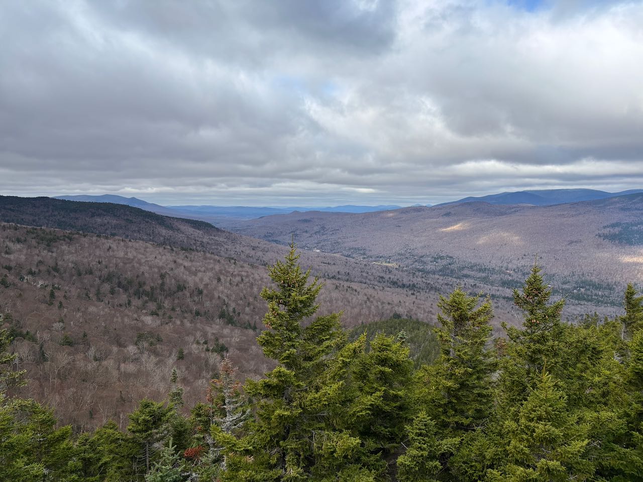
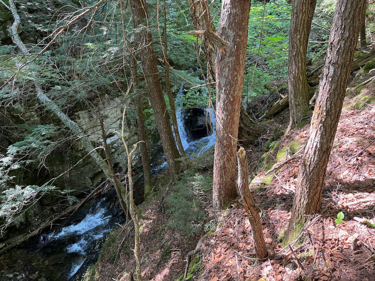
The trail ends at Kelton Trail just beyond the ledge. Turn left to begin descending Kelton Trail. In 0.1 miles, you'll pass a short side path to a viewpoint on the right. This opening has a clearer view to the northewest. Small, rocky Pine Mountain is fully visible as well as the northern slopes of Mt. Moriah to its right. The expansive Bear Mountain in Maine is just to the left of Pine, and the main ridgeline of the Mahoosucs stretches out to the left of that, with many of its major summits appearing in front of one another. Goose Eye Mountain is in the back, with Mt. Carlo in front, Bald Cap in front of that, and Mt. Hayes closest, with Cascade Mountain set off to its left. Mahoosuc Notch can be seen behind Cascade, with Old Speck Mountain all the way in the back. Distant New England Hundred Highest peak Elephant Mountain is visible way in the distance to the left of the Mahoosucs. Trees screen the view to the left of that, but some scattered mountains in the Great North Woods can be glimpsed. Continue on the trail past this last of the viewpoints, and it soon swings right and drops sharply off the ridge over more rocky terrain. It descends rapidly, almost at the same pace as the ascent. After 0.4 miles, it levels off on a plateau and reaches a side path to Kelton Crag on the left. This overgrown ledge now no longer offers any views. The trail turns right here and drops down a bit of a rock scramble before leaving the coniferous forest and moderating out a little. In another 0.4 miles, reach the end of the trail at Howker Ridge Trail, right across from a sign for Coosauk Fall. It can be difficult to see this often-dry cascade on a tributary emptying into Bumpbus Brook through the trees. If you want to extend your trip just a bit, turning right at this junction will take you to Hitchcock Falls in about 0.3 miles. Turn left to complete the loop. The trail follows high along the bank of Bumpus Brook, soon passing a twin cascade pouring into Devil's Kitchen, a mossy gorge with high rock walls. In 0.2 miles from Coosauk, the trail passes Stairs Falls, a short rocky plunge located where another tributary joins the brook. The trail remains beside the brook for another 0.1 miles, passing some ledgy rapids and cascades, before pulling away. Another 0.4 miles downhill, crossing some boardwalk near the end, will take you back to the trailhead.
Printable directions page