


blah blah blah
Dryad Fall
Length: 3.2 miles out-and-backDifficulty (click for info): Easy
Elevation Gain: 850 feet (+20 feet on return)
Rating (click for info): 6/10
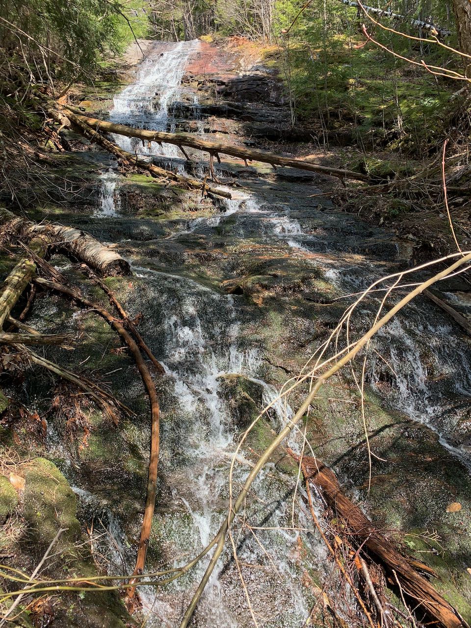
Height: 300'
River: Dryad Brook
Driving Directions:
Trailhead and parking area are at the end of Mill Brook Road in Shelburne, NH (Dryad Fall is in Success). To get there, drive Rt. 2 east from Gorham, and 5.6 miles from the eastern junction with Rt. 16, turn left onto Meadow Road. Drive across the Androscoggin River, and after 0.9 miles, the road makes a sharp curve to the left. Immediately after the turn, turn right onto Mill Brook Road, a rough logging road. Drive for 1.5 miles, staying on the main road as narrower roads diverge occasionally. Near the end of the road bear left and parking in a clearing where the road immediately ends at a stream where there once was a bridge. Park here. Access to Mill Brook Road is not guaranteed, especially in winter, so if the road is shut down, you can use the trailhead for Austin Brook Trail, half a mile further west on North Road (past the curve where you turn onto Mill Brook Road). This would add 1.3 miles each way to your hike. Click here for a Google map.
About the Hike:
Unofficially, the Mahoosuc Range's Dryad Falls is New Hampshire's tallest waterfall, by a wide margin, overtopping Arethusa Falls by over 100 feet. Why haven't more people heard of it before? The answer is twofold - for one, it's not officially the tallest waterfall because of criteria about the water staying in contact with the rock as it drops (making it more of a tiered cascade), and for another, perhaps more consequential, no trail exists to the base of the waterfall. This is quite unfortunate, as the amazing height of this hidden beauty is a wonder to see. There's still opportunity to see the splendor of the falls, however, as the Dryad Fall Trail will take you to a flat spot near the top of the waterfall, where you can enjoy about 55 feet of it. The hundreds of feet of cascading brook below remain invisible, except from afar, where the trail affords you an unusual view from a great distance of most of the waterfall.
Begin your hike from the end of Mill Brook Road. Cross the planks over the brook (in place as of 2023) where a now dismantled bridge once provided further driving access down the road. Take the right fork of the logging road, which is now the Austin Brook Trail. The gravel road ascends lightly, following Austin Mill Brook in the ravine below. In 0.55 miles, the road passes through a clearing, where you can look ahead toward the rolling hills and see most of the height of Dryad Fall (though still the lower part is hidden in the trees!). Bring binoculars to get the most out of the experience. In another 0.3 miles, after crossing a couple small streams, you reach the original trailhead. The trail bears left onto an older logging road at a sign. It climbs uphill at a moderate grade in a strip of trees amidst recent logging activity. It soon crosses through the cleared areas, and after 0.4 miles, turn left onto Dryad Fall Trail, leaving the logging cuts behind. The trail crosses a brook where you can usually see nice cascades coming down the steep hillside. This trail takes a straight course, climbing 0.4 miles across the hillside, to the spur to Dryad Fall on the left. Follow the short spur downhill ot emerge near the top of the falls, at the base of the uppermost cascades. Standing in the middle of the waterfall, you can enjoy up close the stepped cascade at the top, and the smooth waterslide stretching out of sight below you as it steepens. In addition to the waterfall, there is a lovely mountain view out to the Evans Notch region and the foothills in the northern Carter Range.
Printable directions page