


blah blah blah
Chandler Brook Cascades
Length: 9.8 miles out-and-backDifficulty (click for info): Extreme
Elevation Gain: 2860 feet (+160 feet on return)
Rating (click for info): 8/10
Height: 800'
Source: Chandler Brook
Driving Directions:
Trailhead and parking area are on Rt. 16 in Greens Grant, NH (summit is in Thompson and Meserves Purchase). Look for the entrance to the parking area on the west side of the road, 6.3 miles south of the junction with Rt. 2 in Gorham and 1.5 miles north of the entrance to the Mt. Washington Auto Road. Pull into the entrance, marked by a recreation sign for the Great Gulf Wilderness. Drive through an upper lot wtih extra parking, and look for parking in the lower lot, where the drive forms a loop. The trails take off from the far left corner of the loop. Click here for a Google map.
About the Hike:
The Chandler Brook Trail appears to be a bit of an oddity when seen on trail maps. The 0.9-mile long trail provides a route from the deep interior of the Great Gulf, the massive and rugged cirque on the north side of Mt. Washington, to a random point halfway up the Mt. Washington Auto Road. Since the auto road is not open to hikers, the trail would seem to serve no purpose. However, the joy is in the journey on this one. The trail, a steep, rough, and narrow grind that climbs over 1300 feet in under a mile, follows right beside Chandler Brook, one of the multitudes of cascading runoffs flowing down from Mt. Washington. In the category of other long cascade chains on the slopes of the high peaks like Ammonoosuc Ravine Waterfalls, Fall of a Thousand Streams, Sphinx Cascades, and many others yet undiscovered or off-trail, the Chandler Brook Cascades offer scenic delights around every turn, with almost endless waterfalls to choose from along with views into the wild interior of the Great Gulf. The approach to the trail is also an adventure all its own.
From the information kiosk at the lower end of the parking area, walk down the paved path along the river to the suspension bridge. Cross the bridge and get your first look at the rocky river that will be your on-and-off guide through out the hike. Drop down the stairs off the bridge and climb uphill for a bit to reach a junction with Great Gulf Link at 0.3 miles from the start. Bear left and walk along a smooth surface with just a few roots underfoot from the dark hemlocks surrounding the trail. In this section, the trail doubles as a cross-country ski route. The river remains close by on the left. In another 0.3 miles, bear left as the trail detours around a muddy section of the ski trail. The path narrows and runs rough just atop the riverbank, with rapids and little cascades below, crossing one little stream. It then begins to pull away from the river. Passing by a swampy depression, it runs straight through a hobblebush corridor to rejoin the ski trail after 0.4 miles. The trail ascends gently, crossing a couple streams on wide wooden bridges built for skis (these can be slippery in the summer). In 0.6 miles, the trail passes a ski trail junction and immediately after crosses the boundary line into the Great Gulf Wilderness, marked by a sign. With a rockier surface on the trail, continue 0.2 miles, passing a large boulder, to the next trail junction, where the Osgood Trail takes off to the right. The trail now begins to approach the river again, climbing through mossy rocks along the base of an increasingly steep hill. 0.6 miles past the junction, the trail comes out to an opening right beside the water, where you have the opportunity to explore around the boulders in the river. Just beyond this, the trail climbs a steeper pitch up the bank away from the river. At the top of a rock staircase, it moderates and continues climbing with a couple flat sections to emerge in the gravelly clearing at the top of The Bluff, 0.3 miles from the river. You'll get a glimpse of the high mountaintops as you approach the top. Where several campsites exist across a grassy clearing, scramble up to the top of a boulder on the right side of the trail to see the best view. Over the trail to the left, you can just see the top of the Wildcat Mountain Ski Area. Across the valley from you rises the form of Chandler Ridge, which carries the Mt. Washington Auto Road. Off on the right side, you can see where the interior of the Great Gulf wraps around the corner, although you can't see into the valley floor. Mt. Jefferson overlooks this portion of the gulf, while the triangular summit of Mt. Adams is closer on the right side of the view.
Continue on the trail past The Bluff, and you'll soon reach a junction with Osgood Cutoff. Turn left and drop sharply downhill to cross Parapet Brook, a sizeable watercourse, but one that is usually not too hard to step across on large rocks. On the other side, it climbs up to the crest of a little ridge where trees are sparse and the mountaintops can be glimpsed. Stay straight through a trail junction with Madison Gulf Trail on the right and a path to some campsites on the left. The trail drops down again and crosses over the West Branch with the aid of another suspension bridge. Enjoy the view upstream over numerous cascades and chutes. Just up the bank on the other side, the other branch of Madison Gulf Trail turns off to the left, 0.2 miles past The Bluff. After this quick detour uphill, the trail drops back down to the riverside, where just through the trees, several more scenic cascades roar. Step out onto the boulders in the channel of the river for a nice framed view upstream toward the peak of Mt. Adams. Just a bit further up along the river, the trail passes by a large and unusually shaped and positioned boulder known as Clam Rock, another 0.2 miles past the junction. With a broad, flat overhanging face and jagged upper edge in the pattern of a clam shell, if you stand at the right angle underneath the overhang, the steady rushing sound of the river becomes amplified just as with a seashell held to the ear. Continuing on the trail, pass into an extraordinarily lush and mossy landscape where diminutive spruce trees spring up from the hillside all around. The trail stays quite close to the river, with travel becoming more arduous over and around rocks in a narrower pathway. Continue to watch for pretty cascades in the river, as the trail comes alongside a couple openings on the riverbank, including one deep, stony pool. After 0.8 miles, the trail crosses Chandler Brook in a wide and shallow section that could be difficult to get past if water is high.
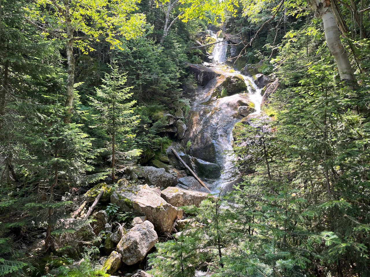
On the other side, turn left at the trail junction onto Chandler Brook Trail, leaving behind most all of what little foot traffic makes it out to this point. Follow the narrow and light footpath through the tangled woods just beside the brook. It begins climbing almost immediately, crossing two stony tributaries where they join Chandler Brook. The trail remains on the bank of the brook for nearly the entire way up, with views of the ever-present cascades not hard to obtain. The first cascades, several tiers of drops over mossy ledges, comes into view after a couple tenths of a mile as the trail makes a narrow sidehill across the mossy mountainside. The cascades are continuous past the first ones, and can be enjoyed while the trail is in view of the brook. After 0.3 miles, the trail passes another significant falls and crosses the brook at the base of another cascade and pool. On the other side, it climbs very steeply, scrambling up through a ledgy slot, and soon emerges by the brook again below a tall and narrow cascade through a jumble of boulders. After a bit more steep climbing, the trail crosses back over the brook, just over 0.1 miles from the first crossing. A view of Mt. Adams is seen over the brook as you cross between a crashing vertical waterfall below and a winding cascade upstream. The trail makes a slight detour away from the brook for a bit, climbing more easily, then contouring across the slope. It comes back to the brook next to another impressive steep-angle waterfall, and soon passes an opening in the trees with a more distant view of a long series of waterfalls upstream. It crosses the brook again a quarter mile past the second crossing.
It begins to climb very steeply through scattered boulders before emerging on a terrace above the brook valley, in a sub-alpine talus patch, 0.1 miles from the brook. It ventures precariously along the boulders as tremendous views open up of the Presidential giants - Mt. Jefferson to the left, the cliffy ridge called Jefferson's Knee just beside the great basin of Jefferson Ravine, grand Mt. Adams across the Great Gulf, and Mt. Madison furthest over to the right. Follow the path carefully as it swings to the left and climbs up out of the scattered rocks and back into the forest. In just over another 0.1 miles, the trail ends at the Mt. Washington Auto Road, where it is barely noticeable and no other trails connect to it. Turn left and walk another 0.1 miles carefully downhill on the road to a pull-off near some nice ledges at the end of Chandler Ridge sometimes called "The Horn". From here, you can enjoy even wider views - out to the northeast to the Mahoosuc Range and east to the Carter Range and upslope toward the summit of Washington - although it is always far more crowded here with the traffic headed to and from the summit.
Printable directions page